I’ll come right out and say it now: I am not an avid app user. Half of the apps I have downloaded on my phone, I hardly ever use (except for my social media accounts). This means that whenever I travel to a new place, I always tend to get all my information online from Gogling on my laptop, rather than searching for relevant apps.
As soon as we got to London last December and knew we would need to take a combination of buses and Tubes, I realised that there had to be an app that could help with timetables or routes. The first one that came up in my search was the Citymapper app and as it had so many good reviews, I decided to download it (let the record show that I do download apps often, only to usually delete them when I realise I don’t like the interface or it doesn’t do what I hoped it would.)
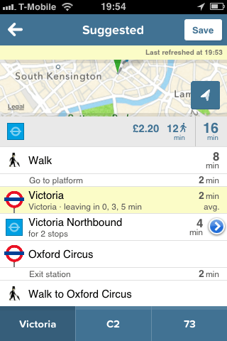
After just a few minutes of playing around with the app, I realised what a little gem it was. I could put in our starting location and our end destination and it would bring up a list of route options, including every different type of transport (bus, train, Tube and walking with a possible bike option too). It would tell me what time the next bus was coming, what time I needed to connect with another bus route, whether I needed to take the Tube or walk and how much it would cost me using my Oyster card. It would also list times for each of these options within the next half an hour or hour, meaning that if I missed the next bus, I could see what time the one after that would arrive. It also gives you an estimated cost of a taxi, should you want to take one.
Oh, and this app also tells you how many calories you would burn if you walked or cycled all the way to your destination and what the weather will be like when you get there. Erm, amazing.
To say that it made getting around the city easy would be an understatement. It also meant that I knew exactly how much balance I would need to have on my Oyster card for the day’s journey before I even left the house, meaning that if I didn’t have enough, I could top it up before I got on the bus and so avoid getting caught short.
If you live in London and take the public transport every day, then this information might not be as crucial to you, as you probably know how much each fare costs. But what if you travel to a new part of the city? Or want to do some sightseeing in a borough that you’ve never been too before? Even if I lived in London and knew the timetables off by heart I’d want to have this app so that I’d always know if there were delays to the line, what time I was due to arrive somewhere and how much it would cost me.
The only downside to the app (as with almost all apps) is that you need a WiFi or 3G connection to use it, so if you don’t have a UK or international SIM card, you wouldn’t be able to use it at the bus or Tube station to change your route, for example. I always used the app on WiFi before I left the house and wrote down which times and routes I was supposed to take and how to get home, meaning that I never had that issue.
Citymapper was honestly a Godsend for us while we were in the city and it’s probably the most used app I’ve ever downloaded for travel, so that’s saying a lot. The best part is, it’s also free. Apparently they have ones for New York, Paris and Berlin which I can imagine are just as useful as this one (pity they rolled out the Berlin one too late for my visit). I can only hope they roll out further versions for other major cities where public transport can be a bit of a maze.
Disclaimer: I wasn’t asked by Citymapper to talk about the app or review it and neither was I compensated for this post. I downloaded the app while I was in London and it proved pretty invaluable for some of our sightseeing daytrips and budgeting. I genuinely used it and loved it, hence why I’m endorsing it here.

Leave a Reply